Almost 90 years after West Vancouverites agreed to development in the Upper Lands, the District of West Vancouver is asking the residents of today to help shape the first major piece of it.
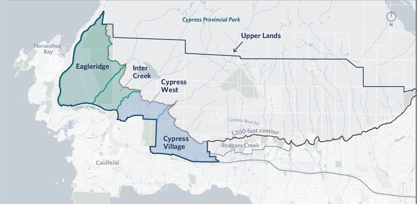
Consultations begin next month for Cypress Village, a new town centre to be built on the slopes of Hollyburn Mountain just west of Cypress Bowl Road.
In 1931, West Vancouver residents voted 1,329 to 26 in favour of selling most of the Upper Lands to British Pacific Properties. The arrangement included cash and payment of taxes for the lands, as well as commitments related to public infrastructure improvements, according to the district. The British Properties neighbourhood as we know it today began construction soon after. Most of the land between the Capilano River and the Sea to Sky Highway is already zoned for single-family homes but has never been developed.
The official community plan calls for Cypress Village to be developed into a denser, walkable community with a mix of market and affordable housing and its own commercial centre so residents don’t need to drive elsewhere in the municipality to access shops, services and work. The proposal going to the public next month would transfer a portion of the development rights from the westernmost 280 acres, known as Eagleridge, to Cypress Village so Eagleridge can be left wild.
“This is really, I think, a departure for some of those more historic subdivisions that we have towards the east,” said Jim Bailey, the district’s director of planning. “I think this an amazing opportunity to protect a really large, beautiful and ecologically valuable area and also create a compact, sustainable new community with diverse housing, which are both goals in the official community plan.”
Over the summer of 2020, the district is seeking the public’s input to help identify which portions of Eagleridge should be first in line for protection and to define the scale and character of the development in Cypress Village. The district will use that input to come up with a draft land use plan and urban design guidelines, including community facilities and environmental protections. By the spring of 2021, district staff hope to have negotiated community amenity contributions required for rezoning and construction.
“Preliminary testing indicates that a community of about 2,500 residential units is needed to support transit service and to protect a significant amount of the land in Eagleridge,” Bailey said. “Those two things are really linked.” Eventually, the district intends to protect all of Eagleridge and a 70-hectare plot of land to the east by transferring more of the development rights but that likely won’t happen for another 20 years.
Bailey acknowledged many residents will likely feel everything above the highway should be left as is, but he said that isn’t on the table.
“Leaving it the way it is isn’t a realistic option. The land is zoned to be developed, and it’s been zoned in that way as per an agreement from the 1930s,” he said. “The main trade-off here is how do we take that and create an opportunity?”
The 2008 Rodgers Creek Area Plan approved by council reduced the amount of greenspace to be developed in exchange for greater density in projects now going ahead.


