North Shore residents and visitors need to start getting used to the idea of a lake where much of the Seymour River used to be.
Following Sunday morning's rock slide near Twin Bridges, it took just six hours to form a new lake that extends 850 metres north from the slide site and six metres down at its deepest point.
"The (geotechnical engineers) are really saying it is what is now. The rocks are not moving. They're just settling down a little bit but that feature will be there," said Mike Mayers, Metro Vancouver's superintendent of environmental management. "It's the largest rock fall I've heard of on the North Shore in a long time."
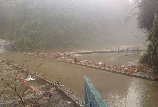
The impact is a permanent change to the geography of the North Shore. The new lake where canyons and rapids used to be has claimed at least two hectares of nearby forest, low-lying sections of the Fisherman's Trail and, as of Wednesday night, the Twin Bridge was submerged.
"We've got flooded forests. Those trees are going to die. They're going to be falling over. We have flooded trails. The water is coming up and down and up and down. We're probably going to lose a few of those. They're going to completely wash away," he said.
Metro crews are now trying to figure out how the bridge can be removed and possibly salvaged.
"We have no other option. It's a permanent feature. It's a lake, not a river and you usually put a bridge over a river," he said.

As a precaution during the heavy rains this week, Metro closed all of the trailheads that lead to the Seymour. The fences and guards should be gone by Friday but Metro is going to be stepping up efforts to keep people away from the slide site and Twin Bridges area, which remain very dangerous, Mayers said.
"There are hundreds if not thousands of trees that are under water. They're coming down all the time. The trail is underwater," he said. "We're going to be putting in place very permanent closures of that very impacted area."
Over the long term Mayers said he expects Metro will look at rebuilding the sections of trail lost to the new lake. That's something the North Shore Mountain Biking Association is looking forward to, according to Vince Beasse, association president.
"We'll have to start working together on what we'll do to put something back or what the future holds for it. They're the land manager, we're the advocacy group so we always collaborate very closely together to come up with some solutions," Beasse said. "We'll be making a plan to restore those community assets."
There's already chatter on the internet about what the new lake should be called, Mayers said. He has an early suggestion.
"Personally, I'm more about the features that created it. At the north end of it, Boulder Creek flows right into it and a big boulder fell down and created it. I'd go with that really imaginative name -- Boulder Lake," he said.
Local hiker Henry Wang shot this video of what the lake looks like shortly after the slide.


