Geotechnical engineers say the massive rock slide into the Seymour River on Sunday occurred naturally.
But it could be some time before we know the full impact of the slide on the local ecology and trails that flank the river.
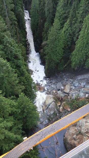
Sometime around 5:30 a.m. Sunday, upwards of 50,000 cubic metres - or 500 dump truck loads - of rock gave way and landed in the river about one kilometre north of the top of Riverside Drive.
"This was actually a significant portion of the canyon wall that was sheered as it came down. These were very large rocks - the size of houses," said Bill Morrell, Metro Vancouver spokesman.
The boulders created something of a natural dam, causing water to form a new pond above the slide area but, Morrell said, water is still flowing through.
"One of the bigger rocks slumped a bit overnight which in fact increased the size of the channel so water's actually flowing better past what was a partial blockage," he said. "That said, it's raining like hell so there's all sorts of water coming down from the watershed."
Geotechnical engineers say the slide was years in the making as small fractures in the rock grew with pressure from seeping water.
"At some point, the crack is large enough and the weight is enough that the slide lets go into the canyon," said Mike Mayers, Metro Vancouver's superintendent environmental management. "It's been evolving over a long period of time.. .. Not weeks but years and years and years."
The good news is the worst of the damage in the canyon appears to be over, he added.
"They've assessed where the slide came from and determined they don't see any other fractures in that area," he said.
The consultants are now focused on determining how stable the boulders in the river are and whether they're likely to be dislodged by high river flows. The North Shore is expected to be under a heavy rainfall warning until Thursday.

Metro Vancouver has closed access to virtually all of the trailheads that lead toward the Seymour River while it swells with extra rainwater. But the trails nearest to the landslide - Fisherman's, Twin Bridges and Homestead - will be closed for the foreseeable future, thanks to the new pond that's formed, Mayers said. On Tuesday afternoon, the pooling water had reached the edge of Fisherman's Trail.
The slide has also likely changed the Seymour River's viability as fish habitat, Mayers said after a meeting with a representative from the Department of Fisheries and Oceans. "It's effectively now a fish barrier and DFO is going to come back," he said. In the meantime, however, district staff and consultants are simply trying to deal with a storm that has made a difficult situation even worse.
"There will be some impacts to recreation we'll have to work on and there will be possible impacts to the fisheries resource," Mayers said. "We just need to get through the (current rainfall) and we can look at those other issues and get the right people at the table."
North Shore resident Henry Wang shot this video from the flood zone above the slide:


