What’s a woonerf? Select your answer from the following:
A: The sound your superannuated sofa makes when you flop down on it
B: A speaker that works in concert with a sub-woofer
C: A living street
D: All of the above
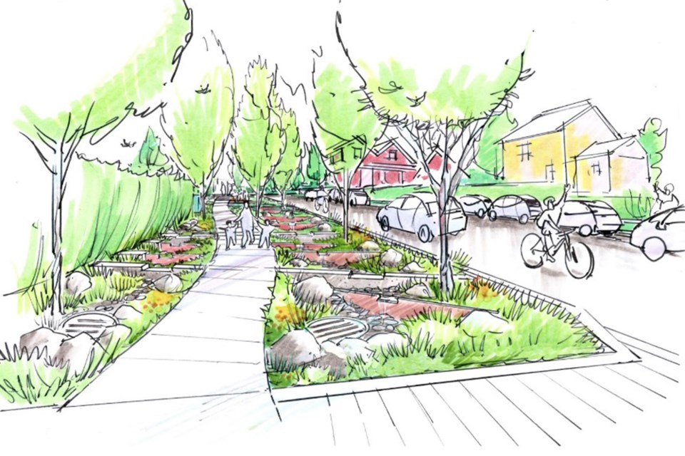
Since this is a column about active transportation, you probably guessed correctly. It’s a “living street” – a translation of woonerfs originating in the Netherlands and Belgium. Living streets include shared space for people, trees, rain gardens, parklets, traffic calming, traffic diversion and lower speed limits. In the city of Vancouver, their “rain city strategy” merges with street design to create living streets.
One project in Vancouver’s Mount Pleasant neighbourhood recently caught my eye. Residents on St. George Street originally wanted to daylight a stream covered by their street long ago. While the daylighting project was deemed unviable, the impetus to honour the street’s watery heritage was transformed into a “rainway” concept. Water basins, swales, gardens, and green spaces for people to enjoy and hang out in for ten blocks will pay homage to the stream locked below.
More than homage, though, the rainway turns rainwater run-off into a valued resource that allows for water reuse, eliminates the need for massive water piping projects as rain events become more violent due to climate change, improves the natural surroundings, mitigates the urban heat island effect, and prevents flooding.
Right, so what does that all have to do with transportation? The St. George living street/rainway project incorporates active transportation. One of its guiding principles is to ensure the safety of all road users. This resulted in some one-way streets in sections, wider walking paths, traffic calming and traffic diversion using parklets.
Naturally, the idea of creating impediments to through travel was controversial. But the citizens made these decisions together. The final design was arrived at by city-guided co-design sessions and public consultation. In other words, residents and regular street users gathered to explore what they wanted to see on their street. They also set design guidelines to ensure access to all lanes and driveways, and for emergency vehicles and garbage collection.
On balance, people agreed that what they gained in new common green space, flood control, and traffic reduction was of greater benefit than car storage and through street convenience.
Not only are living streets more pleasant to live along, but also they are safer. Why? Because eye contact and human interaction (hi diddly ho neighbour) are way more effective than impersonal signs with rules. It seems obvious, but we have used our streets for so long to zoom around in the metal growlers, perhaps we have forgotten how to simply acknowledge each other and make space for trees, plants, streamlets and all the critters that enjoy them as much as we do. Inadvertently, by prioritizing vehicular movement, we gave up more than we got.
Should all local streets in North Vancouver be woonerfs? I say yes. But let’s make a modest start by creating one as a demo. Perhaps another sainted roadway? How about St. Andrews from 24th down to Keith Road? Why St. Andrews? It is the perfect street for a quiet local bikeway and has the space to accommodate more trees, bioswales, rain gardens, wider sidewalks and parklets in addition to parking. There’s not much to lose and a whole lot to gain. Let’s put the woo! into a woonerf here on the North Shore.
Heather Drugge is a sustainable transportation advocate who has used her bike for transportation for more than 20 years. She’s got an e-bike now, and maybe a jetpack next. [email protected]


