TransLink has unveiled the detailed route and streetscape changes required in the City and District of North Vancouver for the Marine-Main B-Line service scheduled to start running later this year.
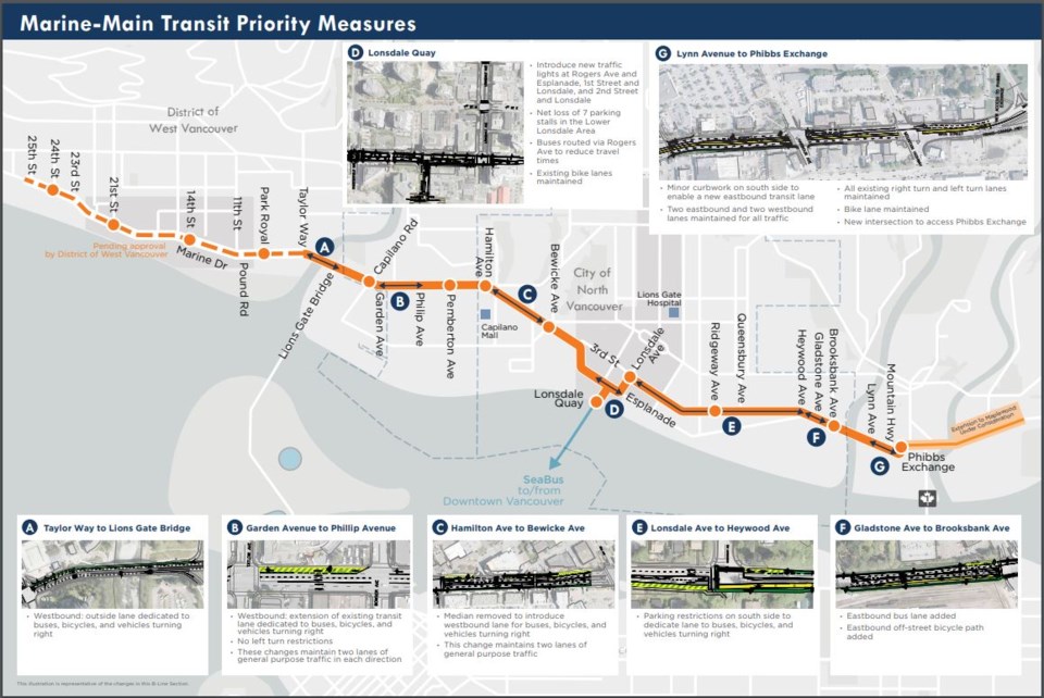
After leaving West Vancouver, the express bus will have stops at Capilano Road, Pemberton Avenue, Hamilton Avenue, Bewicke Avenue, Lonsdale Quay, Third Street at Lonsdale, St. Andrews Avenue, Ridgeway Avenue, Brooksbank Avenue and, finally, Phibbs Exchange.
“It will really transform transit on the North Shore that gives real benefits in terms of travel time to tens of thousands of people a day today … and do so in a way that keeps two lanes of traffic flowing through Marine and through Main,” said Dan Freeman, project manager for the B-Line.
Bus priority lanes and queue jumper lights will be added in stretches that have the most delays for buses, particularly near the bridgeheads. But there will be tradeoffs.
For about 220 metres between the Lions Gate Bridge cloverleaf and the Taylor Way turnoff, buses would have priority access to the westbound curb lane, only to be shared with cyclists and drivers making a right turn.
The bus priority lane that already runs west from Garden Avenue to the Lions Gate will be extended back to Philip Avenue. To achieve this, the project will remove the left-turn bays that mostly lead to residential streets along Marine.
The eastbound stretch between Fell Avenue and Hanes Avenue will get a bus/right-turn/bicycle only lane, which will require the existing median to be removed.
Lower Lonsdale is slated for a number of changes including new controlled traffic lights at Rogers Avenue, where B-Line will access Lonsdale Quay, the removal of parking spots on Esplanade to create room for left turn lanes, and new traffic lights on Lonsdale at First and Second streets.
Heading east on Third Street from Lonsdale, TransLink and the city will create a new bus/right-turn/bicycle lane all the way to Heywood Avenue, which will require the loss of all the street parking on the south side of the street for about 1.6 kilometres, though it hasn’t been decided yet if the parking restrictions would be all day or just during rush hours, as the Broadway B-Line currently operates.
Between Gladstone Avenue and Brooksbank Avenue, the road will be widened to add an eastbound bus lane and a new signal giving buses priority. A new off-street bike lane will also be added.
Lastly, between Lynn Avenue and Phibbs Exchange, buses will be given exclusive access to the inside eastbound lane and the road will be widened to keep two lanes of through traffic.
“It’s a tight area where there are lots of constraints and demands on the corridor,” Freeman said. “Tradeoffs are needed to make the street work better than it does today but we are really pleased the solutions that we’ve come to are ones that actually seem to work really well.
“There are no huge impacts that would cause us to have concerns about proceeding.”
It will be up to the three North Shore municipal councils individually to approve or make changes to the proposed route.
District Mayor Mike Little said the changes will likely be well received by his constituents because it will speed up transit for all the bus routes that use the corridor with little drawback for drivers.
“I’m very optimistic about what the impact will be for the District of North Vancouver,” he said. “It will take some time getting used to the changes in the intersections but that actual traffic capacity will not be negatively impacted.”
According to TransLink, there are about 125,000 people per day whose bus trip will benefit from the bus priority lanes. And the transit authority is predicting more people will choose transit when the new B-Line is up and running, as has been the case with other new express buses.
Little said his main concern with the project is whether the B-Line will attract enough ridership without other express buses feeding into it from across the two North Shore bridges.
Those are planned for the final phase of the 10-year transit expansion program, which does not yet have funding.
“Those would be critical to the success of the B-Line that is funded. So it’s a bit of a cart-and-horse thing to some degree. I wish we had done the bridge ones first but here we go. This is what we’ve got,” he said.
City Mayor Linda Buchanan said B-Line was one of the key strategies identified in the Integrated North Shore Transportation Planning Project as a way to improve mobility and the plan, as presented, has her full support.
“The B-Line, along a corridor designated where people live and work, will cut down travel times for transit commuters and the frequency and speed of the service will encourage more commuters to choose transit for trips along the North Shore, which will free up road space for those who have to drive,” she said in an email.
Buchanan did, however, put District of West Vancouver council on notice. The plan has received a backlash in Ambleside and Dundarave
“I am concerned, though, that if this plan is rejected by West Vancouver, years of efforts to get people moving on the North Shore will be thrown out the window and that any basis for North Shore wide collaboration on effective transportation solutions will be thrown out with it,” she said. “Many people who reach out to me are frustrated to see agreed-upon plans being continually halted by NIMBY eruptions, when those plans are going to make their commutes, by car or by transit, faster and easier.”
See more detailed designs of the North Vancouver B-Line route below:


