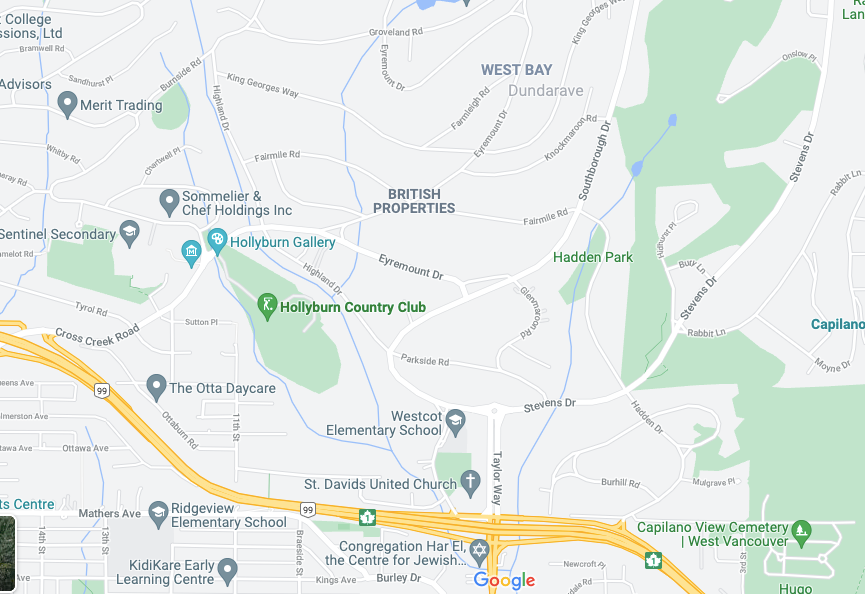
What’s a waterfront West Vancouver neighbourhood best known for its pier and waterfront parks doing plonked in the middle of the British Properties?
It’s a question that’s been vexing author, artist and well-known West Van resident Douglas Coupland since he first noticed the errant neighbourhood on Google Maps a number of months ago.
Like everyone else on the North Shore, “I look at the traffic map three or four times a day,” he said.
At first, Coupland said he assumed it was a temporary glitch that would fix itself. “And then as time goes on, it hasn’t been fixed,” he said. “It strikes me as something really glaring.
“You always expect Google to be right. When Google’s wrong it’s like there is no Santa Claus.”
Coupland said when he zoomed in on the ersatz "Dundarave," Google Maps also appeared to list his own waterfront neighbourhood of West Bay as having also been transported to the British Properties.
Coupland said he tried to alert Google to the error, but couldn’t find a way to suggest a correction to an entire neighbourhood. Corrections appeared aimed chiefly at individual addresses, roads and businesses, he said.
“I think probably there are a few readers who fall under the categories of sticklers,” said Coupland, likening the error to swapping cities like Calgary and Edmonton on a map of Alberta.
“I can’t be the only person who’s noticed.”
Turns out, he isn’t.
Carolanne Reynolds, who heads up Heritage West Van, said she also noticed the mapping malfunction about a month ago.
“We live in Upper Dundarave,” she said. “We’ve now moved to the British Properties.”
Reynolds said she didn’t bother trying to contact Google about the error, but agreed the mistake was annoying.
The stray neighbourhood was news to the District of West Vancouver, however, which hasn’t had the mislabelled Google Maps pointed out before, said spokesperson Michaela Garstin. The municipality’s IT department has now submitted feedback to Google about removing Dundarave from the wrong location, she said.
Garstin added Dundarave also appears on the map a second time in the right location – near the ocean at 27th Street.
She said the public is encouraged to use the district’s own website for accurate mapping information.
Google did not immediately respond to questions about the mapping error.
Coupland isn’t the first person to run into this type of problem. In 2020, a Washington Post writer detailed her family’s experience of having their address show up at two locations on Google Maps – one of them next to a cemetery – and the resulting confusion that created for everyone from taxi and delivery drivers to party guests.
Coupland is famous for novels including Microserfs and JPod which delve into the impact of technology on society. He said questions about how the imposter Dundarave neighbourhood ended up in the British Properties and lack of an easy way to get it fixed “gets into the question of Big Brother and the mysterious nature of Google. Who’s there behind the buttons and knobs?”
Coupland said he’s never spoken directly to anyone at Google on the phone. “How would you ever do that?” he said.
“This is probably more about how we relate with Big Tech than maps,” he said.
“Maybe there are no people,” he said. “Maybe it’s just a big algorithm.”

.png;w=128;h=120;mode=crop)
