A popular West Vancouver trail wiped out by a series of landslides in January 2021 is making a comeback, albeit in a roundabout route.
District of West Vancouver council unanimously approved a plan Monday night (July 25) to reroute the Capilano Pacific Trail and a major sewer line that serves the eastern portion of the British Properties neighbourhood.
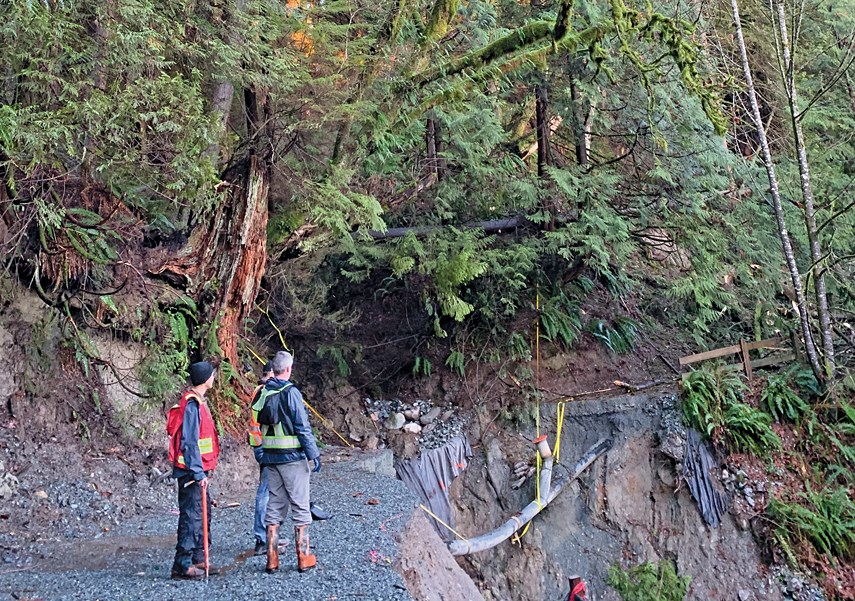
On Jan. 6, 2021 after several days of rain, a slide took out a piece of the trail north of the Upper Levels Highway and left a sewer pipe precariously exposed, which had to be temporarily secured with rope. Subsequent slides in the weeks after did even more damage although a catastrophic failure of the temporary sewer fix was avoided.
After significant research, district staff advised moving both the trail and the sewage pipe to the west, through the woods next to Capilano View Cemetery where they won’t be at risk of future slides.
“There's a contiguous high to very high hazard along the slope containing the previous trail alignment and the sewer alignment,” district engineering director Jenn Moller told council. Moller told council the previously existing trail alignment "is not feasible to construct using conventional practices and a more practical alignment should be sought.”
The bulk of the work will be moving the sewer line – costing about $4.5 million, according to the district’s cost estimates. Piggybacking a 1.3-metre wide gravel trail on top is expected to cost another $800,000.
“The sewer line has to happen. That's not negotiable,” said Donna Power, district spokesperson. “We know it'll be safe for the trail. It will save taxpayers a lot of money. It just makes sense to route them together. It's a good efficiency.”
There will be staircases at either end of the detour, making the new trail portion inaccessible for people on bikes or wheelchairs.
“But we just don't have a way around that,” Powers added.
The decision also helps protect the municipality from legal risk. By adopting a formal policy resolution to decommission the trail and establish permanent razor wire fences and warning signs around the slide site, anyone who trespasses and sues the municipality for injury is less likely to be successful, the district’s lawyers have advised.
Even after putting up multiple warning signs and temporary fences, members of the public still attempt to hike the washed-out portion of the Capilano Pacific Trail. District staff installed a webcam in the most dangerous area of the slide, which captures images of people scrambling through the slide site “regularly,” according to staff.
“It's very dangerous,” Powers said. “It's so dangerous.”
Even though some may miss their walks along the old route, the planned re-routing is better than the current three-kilometre detour via Moyne Drive, Rabbit Lane, Stevens Drive, Mathers Avenue, Third Street, and a new path along the Upper Levels Highway to Keith Road, Powers said.
“I don't think people really enjoyed walking through neighbourhoods on sidewalks and roads. To be able to really put the majority of it on a forested trail…, I think people are going to enjoy that a lot more,” she said.
District council has already budgeted for the work. Construction is expected to begin in 2023.
The 7.5-kilometre trail goes from Ambleside Park all the way to the Cleveland Dam.


