The 7.3-magnitude earthquake hit before dawn, rumbling in from central Georgia Strait. On the North Shore, the ground shook, and large cracks appeared in the walls of the West Vancouver police station.
Asphalt rose in a cracked ridge on the bridge deck over Mosquito Creek. Water bubbled up as water mains ruptured. The shaking triggered a mudslide and rock fall north of Horseshoe Bay, making the Sea to Sky Highway impassable. On the waterfront, a supply line loading ethanol into a rail car ruptured and the fuel caught fire, sending massive plumes of acrid black smoke over the Ironworkers bridge.
Fortunately for local residents, the disaster that unfolded Monday across the North Shore wasn’t real. Rather, the imaginary events that took place were part of an elaborate disaster preparedness training exercise, designed to test how emergency crews would work together with municipal, regional and provincial authorities in the event of a real disaster.
Mike Andrews, emergency planning officer for the North Shore’s Emergency Management Office, designed the imaginary scenarios in Monday’s exercise based on real information about soil densities, building types and demographics that’s been collected from all three North Shore municipalities. That information is then fed into a specialized computer program that models the likely results of a particular earthquake.
Damage predicted by the model became the starting point for Monday’s scenario, designed to test various agencies’ abilities to contain hazards, move key personnel and to prioritize action based on information received.
About 350 people took part in Monday’s exercise – the biggest ever on the North Shore. Results of what was learned will be shared with other emergency preparedness offices around the province.
One of the key assumptions in Monday’s exercise was that the North Shore is likely to be isolated for some time following a disaster.
How to move key emergency crews and resources around if that happens is an issue authorities are actively studying, said Andrews.
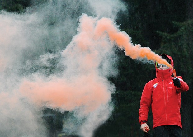
Some of the disaster scenario unfolded at Ambleside Beach in West Vancouver Monday morning, as two helicopters – one from Talon Helicopters and a Bell 429 from the Coast Guard – were guided in by orange smoke flares to land on the grass in quick succession. With a deep, low rumble and massive plume of spray, the Coast Guard hovercraft Moytel also landed on the beach at Ambleside. In a real disaster, the hovercraft - which can set up ramps for roll-off unloading - could be used to transport equipment like an ambulance.
Vancouver Fire Department’s urban search and rescue team also bypassed the bridges to get to the North Shore Monday, loading a command unit on to a barge to get to Ambleside, where they set up a base of operations. In a real disaster, the team is trained to provide expert help to rescue victims trapped in collapsed buildings, using tools that can detect small vibrations behind concrete and a periscope-style camera that can be set to pick up heat signatures.
A large part of Monday’s training exercise focused on the ability of emergency authorities to collect and track information about the unfolding disaster. Understanding “the big picture” is crucial to knowing where to send emergency help first, said Andrews.
One of the tools tested Monday is a smartphone app developed by BC Housing and the University of British Columbia that allows those in the field to upload photos and assessments of damage instantly to the command centre. “In (the Christchurch, New Zealand earthquake) it took 12 to 24 hours of people filling out forms to have usable information,” said Andrews. “We can do it in real time now.”
As part of the exercise, municipal staff were given photos of local street scenes and buildings that had been doctored to look like they might after an earthquake, which were then sent in as damage reports.
The images showed bends in rail tracks, exposed rebar where concrete had fallen away from buildings and buckled roads exposing broken water mains. “So people in here are seeing realistic photos,” said Andrews.
Other high-tech scenarios tested Monday involved using drones to fly under highway bridges and to parts of the North Shore’s reservoir dams to provide instant high-resolution video as initial damage assessment.
Erik Bayfield of Above View Aerial was one of those demonstrating the use of drones Monday as he flew a robot-mounted camera up to examine concrete and supporting structures under the Mosquito Creek bridge.
Permitting for local authorities to use drones for assessment is an issue that has yet to be addressed by Transport Canada, said Bayfield. But he said drones have already been used to gather information in the wake of other disasters like the earthquake in Nepal. Compared to getting a person in place for a first look, drones can usually be sent up much more easily and quickly, he added.
At the emergency operations centre above the North Vancouver RCMP detachment, a low buzz was audible as those in charge examined a large map with colour-coded triangles for events taking place during the mock disaster. They make for sobering reading.
At 12:36 the Lions Gate Bridge is closed. At 12:45 after-shocks hit the region. At 12:56 some low-lying neighbourhoods are hit with liquefaction.
While the drama in the mock disaster is meant to show what could happen, the intent is not to scare the public, said Andrews. “We want them to know that measures are being taken” to prepare, he said.
For the average person, the best preparation is to have a family emergency plan and an earthquake kit on hand. Following a major earthquake, “People need to plan to be self-sufficient for at least 72 hours,” he said. “The system can’t take care of every single person and all their needs. We’ll be trying to do the most good for the people who need it the most.”


