The redesign of Highway 1 in Lower Lynn is finally nearing completion. Phew!
I hear a lot of heavy sighs and some muted woots. People living in Seymour: commence happy dance. Overall, I am not sure whether the changes will have the intended consequence of reducing vehicle congestion. Judging by the lineups on Keith and down The Cut after 3 p.m., maybe not. However, the other goal of this project was safety, and that alone may well have been worth the hefty $198 million price tag. Like one of those Russian dolls, there were projects nested within the main project:
- Mountain Highway interchange: Completed fall 2019
- Keith Road/Seymour Parkway interchange: Completion fall 2021
- Main Street/Dollarton Highway interchange: Completion fall 2021
- Lynn Creek Connectivity Improvement Project: Completion fall 2021
The province kicked in $76.7 million, the feds $66.6 million, and the District of North Vancouver $54.7 million to pay for all this.
Regardless of the success in moving vehicles, there are some interesting new by-products for people getting around on bicycles and foot. A tangle of fresh active transportation paths wind between Brooksbank to the west, Seymour Boulevard to the east, Keith Road to the South and above the highway to the north. These new multi-use paths represent some excellent new links to get around this area more directly and safely.
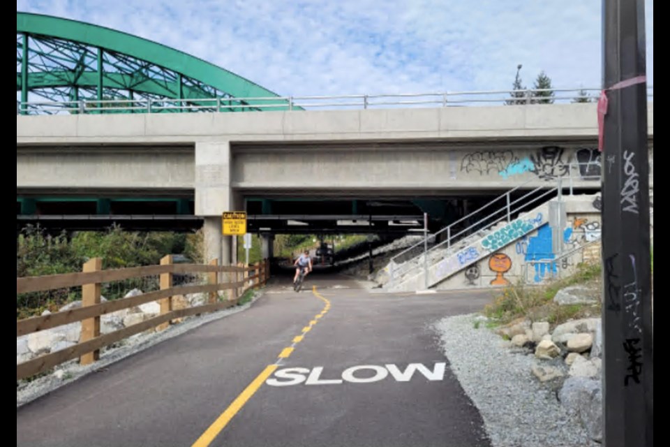
Above Keith, the new path to the west extends the Salop Trail, which runs up the (really steep) hill from Shavington to Brooksbank Elementary. People living in the new town centre at Seylynn can access this path via a new, wide, well-lit tunnel under Mountain Highway. Above Shavington, the trail remains gravel and is steep, so whereas it is great for people walking, people on bikes might not be able to take advantage. The same entrance from Bridgman Park leads under the new Keith Road and Highway 1 bridges to join up with the gravel path on the west side of Lynn Creek. Which again is gravel, so not a super choice for people cycling, but excellent for people on foot.
There are some segments more immediately useful for people on bikes. The path beside Lynn Creek under the two bridges was actually “busy” when I visited. This path links Capilano University to the new town centre and eventually beyond to Iron Workers Memorial Second Narrows Crossing. Students can bike along the path to link up with Old Lillooet Road and then Lillooet.
On exiting the tunnel, you can turn right and hook up to the multi-use path on the north side of the highway where the colourful (controversial?) new sound barrier fencing is going up.
The path along here is a four-meter-wide, two-way, multi-use path. It extends from Mountain Highway to Seymour Boulevard, separating people on bikes and pedestrians from traffic and shielding them from highway noise where the sound barrier exists. To the north, the route takes on a distinct look with alternating flat patches of concrete and asphalt, presumably to help people in mobility devices wheel up this steeper section with rest stops. Or they are someone’s idea of speed control.
To help people navigate the middle of the interchange area, a tunnel invites users to ascend a curving path that ends up on the south side of Mount Seymour Parkway. Once at the top, you can turn east toward the Real Canadian Superstore, or west toward a huge new bridge that connects to Fern Street.
Hats off to the people at the Ministry of Transportation and Infrastructure and the District of North Vancouver who worked hard to incorporate active transportation into a behemoth vehicle-focused project. Before this, anyone who had ever tried to shop at Superstore on bike or foot needed an underwear change – especially if you lived just across the highway on Fern Street.
So where to now?
First, I hope that these active transportation path “stubs” will be extended further. For example, the path on the north side of the highway that leads up to Mountain Highway ends (bump) unceremoniously about 50 feet from the turn-off to Lynn Valley.
Likewise, moving east to the parkway, the multi-use path just stops at Seymour Boulevard. No doubt the district will at some point extend these links.
Second, in the active transportation world, we generally look at multi-use paths with skepticism due to the varying speeds of different users. While initially, MUPs may work well, we might eventually need to separate people walking from people cycling. But not today.
The best way to take advantage of the new paths is to walk or bike over there to experience them yourself. Happy new highway trails.
Heather Drugge is a sustainable transportation advocate who has used her bike for transportation for over 20 years. She’s zooming around on an e-bike now, and maybe looking at a jetpack next. [email protected].


