The city, along with the proponents behind developments at the Jericho Lands, shared some of their ideas for the future on Monday, Oct. 18.
Two designs are being proposed for the land, each bringing with them massive buildings (including three 38-storey "sentinel" buildings), public spaces and up to 18,000 new residents.
The 90-acre area sits in Point Grey, between West 4th Avenue and West 8th Avenue on the north and south, and West Point Grey Park and Highbury Street on the east and west. The land, which is made up of two property parcels, currenlty houses things like Jericho Hill Disc Golf Course, the West Point Grey Academy, and Jericho Hill Centre.
The land is currently owned by two corporate entities: the MST Partnership (which is a partnership between the Musqueam Indian Band, Squamish Nation, and Tsleil-Waututh Nation) and the Canada Lands Company (CLC), which is a federal crown corporation. The eastern parcel was transferred to the duo in 2014 from the Department of Defence, while the western piece was transferred in 2016 from the provincial government.
Now entering Phase 3 of the redevelopment process, the city is looking for feedback from the general population on the proposal and the policy guiding it.
"The policy statement will create a framework which will guide future redevelopment of the site and help create a new community that is sustainable, socially and culturally inclusive, and highly livable," states the city on its website.
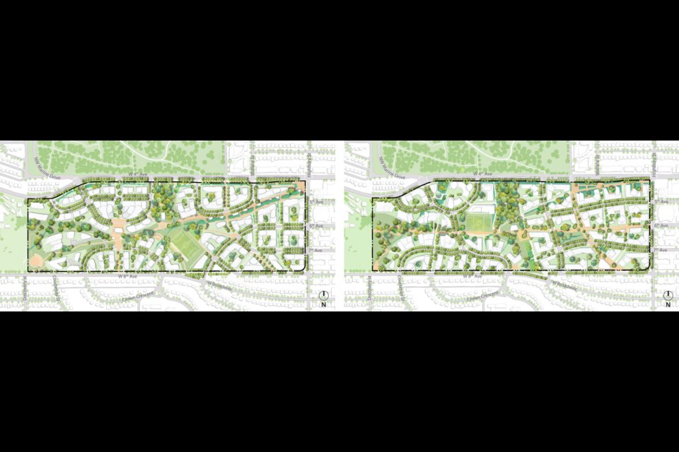
The proponents have presented two different designs for their proposal. Both are relatively similar, looking to create a community with around 9,000 new residential units (20 per cent would be social housing, 10 per cent rental), along with commercial and mixed-use areas. Both include pedestrian walkways through the area, a sports field and parkland/public space. Neither includes major roads or industrial land of any sort.
One, called Eagle, centres on one main walkway running from the southwest corner to the northeast corner of the development.
"The diagonal creates a flight along a pedestrian walkway lined by a ‘waterway’ wing to a central park and travels up to a mixed-use urban plaza and a potential transit station," state the proponents, connecting the design to the eagle, an important symbol to the three First Nations involved.
The eagle design would cluster the tallest buildings in two specific areas, one to the west and the other to the east of the land, with a large gathering space (which would include parkland and the sports field) in the middle.
"Both high points are located inwards from the site edges, with height transitioning down toward adjacent existing neighbourhoods," note the proponents.
A highpoint to the west would offer views of the area.
"The ridge, toboggan hill, a portion of the existing natural area and many significant existing trees are retained, enhanced and celebrated, and new tree canopy is added," state proponents.
Commercial land would be mostly kept to the northeast corner near West 4 Avenue and Highbury Street and to the base of the three sentinel buildings northwest of the central plaza.
The overall design would integrate with the current topography of the site.
The other design, known as the weave, would divide the area up into smaller pieces, design-wise. Three separate areas would be the "hearts" of the community. The weave idea would be noticeably present in the network of roads and pathways through the new community with many small park areas. A main east-west pedestrian and cycling route would connect to more north-south paths, and cars would be able to (slowly) travel from West 8 Avenue to West 4 Avenue.
Small scale commercial areas would be more spread out than in the eagle design, with mixed-use areas and the sentinel buildings again in the northwest quadrant.
"Cultural spaces (art, nature, food security, education) are located adjacent to an enhanced natural area and central park within the Nature Heart, combining a focus on Indigenous knowledge, gathering spaces, and food security," write the proponents.
A SkyTrain station and transit service are also planned to be integrated into both designs. The Broadway Subway project is currently being built to Alma Street, one block east of the edge of the Jericho Lands. Future extension of the subway would likely include a station connected to the new development.
School and community amenity needs are also being discussed in Phase 3.
As Phase 3 continues "we will begin to better understand the potential package of public amenities that will be delivered," state the proponents. "The public amenity package is being developed as part of the planning process, which will incorporate public feedback and analysis of existing and planned amenities in close proximity to the site."
Jericho Lands Phase 3 Kick-Off - Oct 18, 2021.mp4 from Canada Lands on Vimeo.


