Metro Vancouver residents may see some snow next week—but it's very unlikely that any of it will stick to the ground at lower elevations.
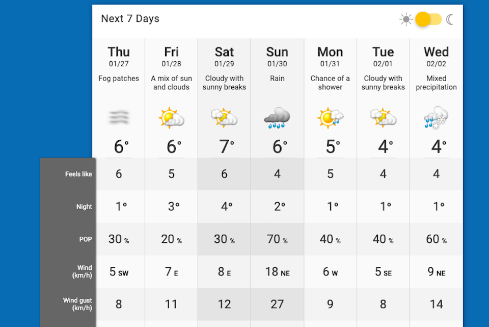
Environment Canada meteorologist Doug Lunquist told Vancouver Is Awesome in an interview that locals will see a change in the weather this weekend. Precipitation will return to the region on Saturday (Jan. 29) and overnight lows will dip down around the freezing mark, which means there could be some snow mixed with rain at times.
Higher terrain is more likely to see snow, he adds, noting that "more rain on the North Shore is good for the ski hills there."
While a ridge of high pressure has provided Metro Vancouver with some sunny periods, low clouds, and fog since the weekend, it is expected to switch to "straight rain" on Saturday. Following that, the meteorologist forecasts a showery period from Sunday through Tuesday.
Daytime highs are trending at the average for this time of year, which is about 7°C. Until Friday, overnight lows will dip down near freezing but are expected to rise up a couple of degrees next week.
Lundquist notes that Metro Vancouver typically only sees one period of truly cold winter and that there are usually only one to three arctic air events per year. Moving forward, the region could have another cold-weather event in February or March; he doesn't see any extreme cold moving into the region in the 10-day forecast.
But arctic air that moves into the Lower Mainland in February or March won't be as cold as the temperatures the region saw in December, he emphasized. "That is impossible."
Is there a fool's spring in Vancouver? Find out more information about winter in the city and this term.