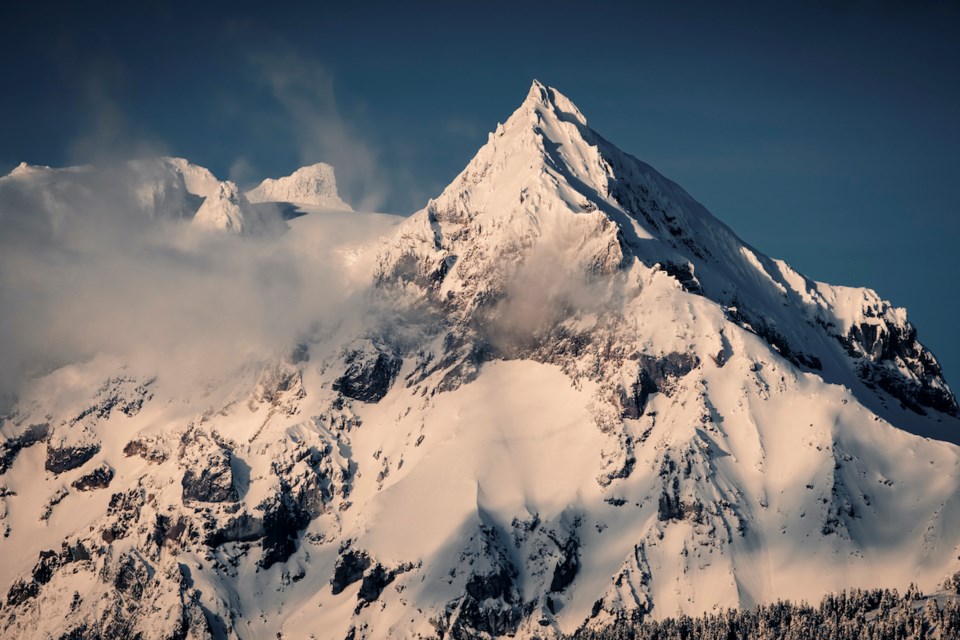
Two academics have compiled past research and the known history Mount Garibaldi (Nch’kay) into a comprehensive paper that ultimately calls for further research into the volcanic system.
The authors of Mount Garibaldi: hazard potential from a long-dormant volcanic system in the Pacific Northwest, Conner Morison and Catherine Hickson, outlined the potential hazards for Squamish, as well as the rest of the Sea to Sky Corridor if the system were to erupt.
The key takeaway from the research is that a better understanding of the history of eruptions from Mount Garibaldi, which is known as Nch’kay in the Skwxwú7mesh language, can inform future risk.
A volcanologist with the federal government says more research about the volcano began last summer.
“You can detect minor earthquake activity happening sometimes years, sometimes even decades before anything happens on the surface,” said Morison in an interview with The Squamish Chief. Morison is currently a PhD student at the University of Edinburgh and conducted the Garibaldi research with the University of St Andrews.
“The issue with Garibaldi is that we wouldn't be able to detect that just now because it's not monitored closely enough,” he explained.
Morison said that Canada’s seismometers have the capability to measure large earthquakes — like the “Big One” — but are not designed to pick up earthquake activity in a volcanic system. He added that it remains unknown whether a magma chamber still exists in Garibaldi; without one, he said, the chances of an eruption are extremely low.
A magma chamber is a reservoir beneath the surface that contains molten rock.
According to Natural Resources Canada, its seismometers could potentially detect small earthquakes despite not initially being designed to do so.
“Canadian volcanoes lie within a regional network of seismometers,” wrote Melanie Kelman, a volcanologist with Natural Resources Canada, in an email to The Squamish Chief. “Although this system is not optimized for volcano monitoring, it does have the potential for detecting the many very small earthquakes that might occur if a volcano became restless.”
Optimal monitoring would be a network of stations tracking earthquakes and ground deformation, but “due to high costs … very few volcanoes around the world are monitored at this level,” Kelman explained further.
Additionally, Kelman wrote that Natural Resources Canada is developing the use of “InSAR (Interferometric Synthetic Aperture Radar), a satellite-based system, to monitor multiple Canadian volcanoes for deformation that may indicate volcanic unrest.”
When asked when InSAR technology would be developed, Kelman explained that a prototype is already in place and monitoring Garibaldi.
“We are still refining the system of collecting, processing, and interpreting data, and are developing a workflow for how we interpret and act on any surface deformation that we see,” she wrote.
On the other hand, Kelman confirmed that it was still unknown whether or not a magma chamber existed at Garibaldi. She wrote that the geological mapping and sampling already conducted may help determine if one is present.
Ideally, the likelihood of an eruption will be determined by a federal project
“If we had more dates about when eruptions happened and how long it went quiet for then we might be able to say more about the likelihood,” Morison said.
Fortunately, Kelman said that just last summer research about Mount Garibaldi began, which is part of the Volcano Risk Reduction in Canada project spanning 2022 to 2025.
A key activity of the project is “developing a hazard and risk assessment for Mount Garibaldi (Nch’kay), which will allow us to better understand how the volcano behaves over long time frames (hundreds, thousands or millions of years), how often the volcano erupts and how large eruptions are,” she wrote. “This will help us determine what areas could be affected by different types of hazards.”
If an eruption were to occur, some of the hazards identified in Morison and Hickson’s research include lava and debris flow, pyroclastic density currents, forest fires, tephra fallout and lahars.
Pyroclastic density currents are “hot, ground-hugging flows of ash and debris” that can travel up to hundreds of metres per second, according to the British Geological Survey.
“Pyroclastic density currents may be produced when unstable lava domes collapse,” reads the research from Morison and Hickson. “The fringes of Squamish are constructed upon suspected evidence of this hazard.”
Tephra fallout includes rock fragments launched from the volcanic eruption plus ash and fragments dropping to the ground. Lahars, on the other hand, are a mix of meltwater, debris and possibly tephra that flows to lower levels and can set like concrete.
“The rapid expansion of Squamish as a commercial and residential centre is expected to increase its vulnerability to potential environmental hazards,” reads the research.
As such, Kelman said the hazard and risk assessment of Garibaldi will be completed before March 2025 and will be essential for “informed land use planning and emergency planning.” Additionally, monitoring will go on beyond the end of the project.
The threat level of Garibaldi
Although the volcano has been quiet for a long time, Mount Garibaldi is considered to be a high-level threat in Canada.
“10,000 years is a long time for a volcano to be quiet anywhere,” said Morison. “But it's not that long that you could call it extinct because it's still on the same tectonic zone as many other dangerous volcanoes.”
Based on formal rankings conducted in Canada in 2021, Kelman wrote, “Two Canadian volcanoes, Mount Garibaldi (Nch’kay) and Mount Meager (Qw'elqw'elústen) ranked at the low end of the Very High category.”
The rankings were based on geology and exposure factors. Geology factors, for example, would be how often a volcano erupts and how large or explosive the eruptions were. Exposure factors were based on such things like how close people and infrastructure were situated near a volcano. Together these factors provided an overall score.
“It’s important to remember that because of where volcanoes and other natural hazards occur, we can’t avoid the risks entirely, but we have many options for reducing these risks through hazard and risk assessment, monitoring and other activities,” Kelman wrote.
Provincial and local volcano monitoring plus emergency response
Although volcano monitoring is largely a federal government task, the provincial Ministry of Emergency Management and Climate Readiness (EMCR) reports that it has a system in place with the federal government if the onset of volcanic activity were to occur at Mount Garibaldi.
Subsequently, the District of Squamish reports that it maintains close contact with EMCR as well.
When it comes to seismic monitoring, EMCR spokesperson Krystal Thomson said the federal government is continuing to develop a national earthquake early warning system, with the first sensor station already being placed in Horseshoe Bay in March 2022.
Thomson said the hope is to have the system fully operational in B.C. by the spring of 2024.
District of Squamish spokesperson Rachel Boguski told The Squamish Chief that the District has also been working with a team at Simon Fraser University focused on volcano risk reduction, which also monitors ground surface deformation through satellite imagery.
“This work will help to inform the District’s future engagement strategies on community emergency preparedness,” wrote Boguski.
In the statement from the EMCR, Thomson encouraged all residents to have emergency kits and grab-and-go bags available and to follow local or First Nations authority if an emergency arises. Similarly, the District encouraged locals to know their evacuation zones and also sign up for Squamish Alert for emergency notifications.
Learn more about Squamish Alert at the District’s website.
**Please note that the photo was swapped out for a different one after the story was first published.


