The City of Delta is going to give residents an opportunity to meet in-person to provide input on the major River Road West Flood Management Strategy project.
Council last week agreed with a staff recommendation to hold in-person public consultations when restrictions are lifted to address concerns raised during a recent online consultation.
The opportunity to have an in-person consultation was not available due to the COVID-19 pandemic.
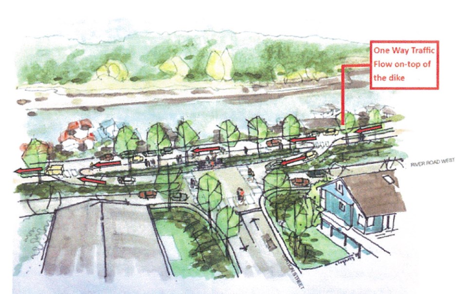
The city’s plan is to address long-term flood protection while creating a series of roadway changes from 34th Street to Ashbury Place.
The proposed changes include traffic calming in the form of raised intersections to reduce speeding on River Road West, a provision for vehicle access and resident parking on a dike roadway, a continuous multi-use pathway allowing connections to the Westham Island Bridge and Brunswick Point, improved resident access through raised intersections to allow for a more gradual transition to the dike roadway as well as consolidating access points by reducing the number of driveways.
The ultimate goal is to raise the dike by approximately 0.6 metres by 2050 with provisions to raise the dike a further 0.6 meters by 2100.
A report to council notes some of the concerns raised during the online feedback included the proposed parallel parking on the dike road being too narrow, beautification encouraging more tourists, a loss of existing on-street parking, access impacts to driveways on the water side, especially in the Canoe Pass area, emergency vehicle access for the areas with one-way traffic along the dike road and pedestrians and cyclist access to the multi-use pathway crossing the dike road.
The report notes staff will work a consultant to further refine the conceptual design based on the feedback received and organize an in-person consultation prior to finalizing the flood management strategy.
“This strategy is the initial phase of planning ahead of future upgrades. Given the magnitude of the work required and costs associated with this type of infrastructure, it is likely that the strategy will evolve and change over time prior to any construction taking place,” the report adds.
Two years ago, city council agreed with a staff recommendation that the city enter a memorandum of understanding with the Ministry of Forests, Lands, Natural Resource Operations and Rural Development for a phased flood protection strategy.
It’s to provide clarity for residents that own property along the river as well as provide staff sufficient time to complete a comprehensive study of the corridor.
Many properties in the River Road West area, which encompasses Port Guichon, are shallow and located outside Delta’s dike system.
An engineering department report at the time explained that when provincial dike guidelines were amended to address climate change and dike seismic design guidelines were established, it was determined the entire dike system would need to be raised significantly by 2100.
The department suggested that a phased approach be implemented.
However, property owners raised the alarm, saying the situation left them with great uncertainty as they’re likely unable to redevelop or rezone their properties because the city will need part of their land.
The city is now saying a new conceptual design were developed in an effort to avoid additional private property requirements by ensuring the proposed flood protection improvements would be undertaken within existing road dedications and statutory rights-of-way.
Council was told funding is not even in place but a conceptual design should be in place if dollars become available.


