The District of West Vancouver is one step closer to deciding what should become of a large swath of undeveloped land on the hillside above the highway.
In the Upper Lands, between the British Properties and Cypress Provincial Park, exists a blank canvas — 6,000 acres of public and private property representing just over one-quarter of West Van’s total land area.
The question is: how will the stakeholders plan for a sensitive ecosystem, recreational opportunities and future neighbourhoods to coexist in harmony in the Upper Lands territory?
Preserve as much parkland as possible and concentrate density in a small area near the base of Cypress — those are the chief recommendations of a citizens’ group tasked with revisiting the findings of a council-commissioned Upper Lands study from a decade ago.
Those findings informed the district’s 2004 official community plan, which in turn informed the Rodgers Creek residential plan, and all other future decisions involving the Upper Lands.
The purpose of reopening the dialogue now is to seek more clarity for the Upper Lands plan, to incorporate new environmental data and to integrate new district policy such as the Parks Master Plan.
Starting in 2012, the Upper Lands Working Group engaged community interest groups and the general public to help inform the recommendations outlined in their draft report released last week.
“Working groups can step outside of the day-to-day operations of the municipality and look at the big picture from a citizen’s perspective,” explained David Hawkins, a district senior planner who served as a staff liaison to the group.
The group’s chief suggestions for the Upper Lands include not allowing development above 1,200 feet or west of Eagle Creek, and shifting density over to the future Cypress Village, thereby preventing a housing sprawl.
Protecting municipal property above the 1,200-foot elevation point — the most ecologically sensitive area — should also be a priority. That leaves the potential for a future 3,000-acre park in that area.
British Pacific Properties owns most of the property below 1,200 feet, but also has some significant holdings above that elevation line. It’s being recommended that the district purchase private lands above 1,200 feet that abut their property.
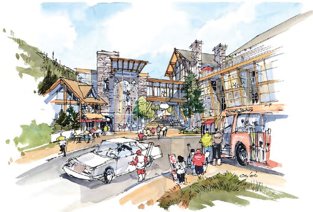
Meanwhile, the concept of a mixed-use mountainside village with restaurants, shops and a diverse housing mix at the base of Cypress is quite exciting to working group co-chair Ashley Willard Bauman, who has worked on master plans for communities around the world.
“I think Cypress Village has the opportunity to create something we are not seeing in the world right now — a wonderful mixed-use urban village that becomes like a gateway to a mountainside that is 20 minutes from a downtown centre,” said Bauman.
The idea would be to connect relatively adjacent Rodgers Creek with Cypress Village through a trail system.
“It’s only logical that you connect them up,” said Coun. Michael Lewis, while weighing in on the Upper Lands draft report. “This idea of trading density on the far west of the community for more density around the proposed potential Cypress Village area — that makes a lot of sense.”
Planning for Cypress Village could begin later this year, said Hawkins, who added that it’s up to council to guide those decisions based on the Upper Lands report.
In terms of recreation, a trails plan for the Upper Lands — a haven for mountain bikers and hikers — is being recommended. According to Hawkins, there is ongoing dialogue between the district and some of the user groups.
The working group will present its draft recommendations to the community at a series of open houses starting April 11. There will also be an online survey from March 20 to April 19. More information is available at westvancouver.ca/upperlands.
The Upper Lands final report is expected to go before council in June.


