West Vancouver bathed in sepia tone has a starring role in a video that’s gone viral, giving older viewers a trip down memory lane and younger generations a glimpse into the past.
In 1966, summer students were first hired to map B.C.’s entire road system on 35-millimetre film for the Ministry of Transportation. The students had no idea the fruits of their labour would half a century later reach more than 100,000 people through the click of a button.
The footage was uncovered a few years ago by a pair of enterprising Ministry of Transportation employees who devise web and social media content. Rumour had it there were film canisters harbouring a transportation time capsule at the B.C. Archives office.
“It came to us in 16-millimetre reels and we quickly realized the ministry didn’t have a 16-millimetre projector to see what was on the reels,” said Kristen Reimer.
Reimer and her colleague James Penner embarked on a bumpy mission to uncover what was on the reels. After four weeks of scouring a Victoria buy-and-sell site to find a projector, they learned of such a relic languishing in someone’s basement.
The history enthusiasts plunked down about 50 bucks for the projector, after convincing their superiors at the ministry that it was a good investment.
But, once they turned on the machine, the light bulb broke. So back to the internet they went to track down a rare light bulb, which arrived from New York two months later.
Once Reimer and Penner got all the pieces together they went into a boardroom on their lunch break to see what images had been buried for all those years.
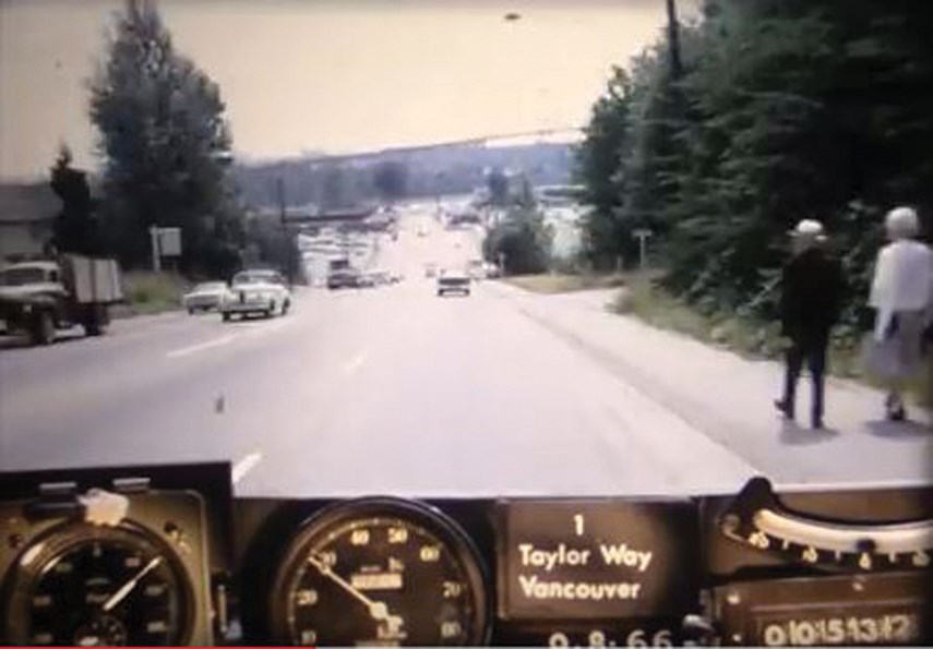
The scene opens in Horseshoe Bay and takes the viewer on a 1960s cruise eastbound along Highway 1, across the Lions Gate Bridge and into downtown Vancouver.
The speedometer needle dances steadily between 40 and 50 miles per hour on the Ford Falcon. It’s rigged with a camera system on the dash to automatically capture still images every 26 metres.
Those 35-millimetre pictures were later looped together into a film, which ministry engineers would watch to identify deficiencies in the road system and plan for transportation upgrades.
Fast-forward to 2017 and the rare footage, shot before the proliferation of video cameras, also serves a nostalgic purpose. On their smartphones, viewers swoon over the 1960s scenery.
Juvenile trees fringe the roadside and there are large gravel shoulders. A sign appears: Vancouver Turnoff in Half a Mile. The metric system wouldn’t be introduced until four years later in 1970.
As the film reel ticks along, stark differences on Highway 1 in West Vancouver then and now stand out to Reimer: only one lane in both directions, no Upper Levels Highway and a lack of development along the roadside.
There are also familiar comforts on the film, for Reimer, who grew up in the Greater Vancouver area.
“I like the idea of coming down Taylor Way and seeing the Park Royal mall – it’s something that’s always been there,” she said.
On the film you see an older couple strolling down an uncongested Taylor Way. The viewer is left wondering where the couple was going that day and what was happening in the world at that time.
“And that’s what I like the most, seeing the people in the landscape as you move through it and getting a sense of the human aspect of it,” said Reimer.
After crossing the Lions Gate Bridge a number of notable landmarks on Georgia Street come into view on the film, including Christ Church Cathedral, Hotel Georgia and the Hudson’s Bay building.
The industrious duo digitized the old footage, cleaned it up and pared it to a three-and-a-half-minute clip, which has since amassed 100,000 views on the ministry’s YouTube channel.
This latest video is one in a series of historical B.C. road trips the ministry has created from millions of miles of footage.
Reimer said they have only worked their way through one box of 1966 reels, and this photo log road mapping was done every couple of years. Once they get past the 1960s, the plan is to roll on to the 1970s with this digital archiving project.
These days, the ministry uses a specialized van called an automatic road analyzer, outfitted with computers, lasers, GPS and high definition cameras to collect transportation data.


