West Vancouver council has endorsed a laundry list of recommendations that will determine the future of 6,000 acres of public and private property above the highway between the British Properties and Cypress Provincial Park.
On Oct. 28 council members unanimously decided recommendations contained in Part 1 of the Upper Lands Study Review Working Group’s final report be used as a framework for Upper Lands policies in the OCP, to plan for a future Cypress Village and to develop a recreational strategy.
Chief among the Upper Lands group’s recommendations, of a total 29, calls for the restriction of residential development above the 1,200-foot contour line, the most ecologically sensitive area, and that municipal lands above that point be reserved as dedicated parkland. A related directive recommends any residential development opportunities west of Eagle Creek be transferred to lands east of Eagle Creek.
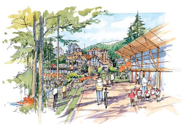
A future mixed-use development at Cypress Village should be a gateway to recreation and complemented by a variety of shops, services and community amenities, built around diverse residential including affordable, rental, family and seniors housing.
Council offered appreciation towards the working group members and their two and a half years of consultation with stakeholders and the public. The meeting was also a chance for council members to ask questions about the Upper Lands recommendations.
Coun. Nora Gambioli expressed concern with how fast the Cypress Village plan is advancing, saying she has heard from some community members that the project is not a priority. Gambioli noted there are 15 other major projects in the planning department outside of the Upper Lands. “So, my concern is how staff is going to reconcile this great work that you’ve done with all the other planning work we have to do, and how are we going to prioritize that?” said Gambioli.
Coun. Mary-Ann Booth pointed to the results of a public survey that asked if the 1,200-foot contour line for development restriction should be finite. Booth said 37 per cent of survey respondents voted in favour of an inflexible line, 41 per cent voted against and 22 per cent were undecided. Booth then asked the municipality’s senior community planner David Hawkins where the rationale for the development boundary in the Upper Lands came from, saying “it’s hard to draw conclusions from those numbers.”
Hawkins explained those results were from an earlier stage in the working group process, and subsequent public engagement showed a higher level of support for the inflexible line.
Representatives for British Pacific Properties, the single largest private land owner in the study area, outlined their concerns with the recommendations through a letter to the Upper Lands working group.
British Pacific Properties president Geoff Croll referred to specific recommendations as being “too definitive or prescriptive,” adding that because public feedback was not conclusive on development above the 1,200-foot marker, it’s too premature to dismiss it.
Croll gave the example of Pinecrest Drive, in the British Properties, which follows the 1,200-foot contour. There are single-family homes on the south side of the road, but no development on the north side – an area that Croll says is not environmentally sensitive.
Croll wrote that eliminating the potential for development in the area without more detailed analysis could potentially “short change” the community as well as British Pacific Properties.


